


st helene boucle G1

papou73
User
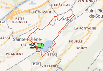

Length
8.6 km

Max alt
352 m

Uphill gradient
158 m
Km-Effort
10.7 km

Min alt
256 m

Downhill gradient
158 m
Boucle
Yes
Creation date :
2021-10-11 06:20:25.65
Updated on :
2021-10-11 08:58:19.356
2h11
Difficulty : Medium

FREE GPS app for hiking
 SityTrail
IGN / Geographical institutes
SityTrail Plus
The world is yours!
About
Trail Walking of 8.6 km to be discovered at Auvergne-Rhône-Alpes, Savoy, Les Mollettes. This trail is proposed by papou73.
Photos


Positioning
Country:
France
Region :
Auvergne-Rhône-Alpes
Department/Province :
Savoy
Municipality :
Les Mollettes
Location:
Unknown
Start:(Dec)
Start:(UTM)
270976 ; 5040217 (32T) N.
Comments